Artist’s rendition of PFOA. Students should not be drinking PFOA on campus.
October 3, 2026
Dear President Vargas and CSUMB administrators,
California State University Monterey Bay was created on the grounds of former Fort Ord. That history brings an obligation larger than ordinary campus management: the University must insist that the soil, water, and construction zones used by its students, staff, and neighbors are investigated with current science—not assumptions made by the Army before PFAS was even part of the regulatory vocabulary.
Independent September screening identified PFAS at four locations connected to campus life and former Fort Ord land uses.
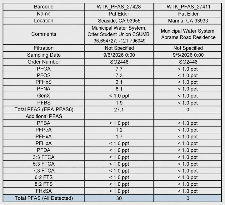
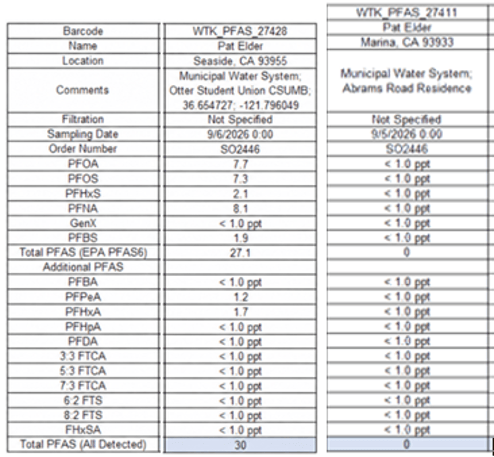
A tap-water sample from the Otter Student Union contained 7.7 parts per trillion (ppt) of PFOA and 7.3 ppt of PFOS. Both exceed the EPA’s current individual drinking-water maximum contaminant level of 4 ppt. The same sample contained PFNA, PFHxS, PFBS, and other measured PFAS, with 30 ppt total detected PFAS.
Another sample collected from a residence on Abrams Drive in Marina, a litttle more than a mile away showed no detection of PFAS. How could that be?
Certainly, one sample does not establish system-wide compliance or prove anyone’s illness was caused by water at the Student Union. It does, however, require prompt confirmatory sampling, disclosure of the source water and distribution route, and a public explanation from CSUMB and Marina Coast Water District.
PFOA deserves particular attention.
PFOA is not simply another PFAS on a laboratory printout. The International Agency for Research on Cancer classifies PFOA as carcinogenic to humans—a conclusion based on sufficient evidence of cancer in laboratory animals, strong evidence of carcinogenic mechanisms in exposed people, and very strong human evidence for kidney and testicular cancer. The National Toxicology Program has also concluded that PFOA, like PFOS, is presumed to be an immune hazard to humans. California lists PFOA as causing cancer and reproductive harm. It is fair to say that PFOA is among the most thoroughly studied and consequential PFAS compounds.
A 2025 peer-reviewed journal article published in Journal of Exposure Science & Environmental Epidemiology, funded by the NIH, tracked millions of US residents. It observed where PFAS drinking water contamination corresponded with elevated incidences of hematologic malignancies, including leukemia and myeloma, especially in male populations.
A Maximum Contaminant Level Goal, (MCLG) is the EPA’s non-enforceable, health-based drinking-water goal, set at the level where no known or anticipated health effects are expected. For PFOA, EPA set it at zero. Students should not be drinking these carcinogens.
When I spoke with Dr. Linda Birnbaum, the former director of the National Institute of Environmental Health Sciences and National Toxicology Program, she warned that the relevant question is not whether a concentration looks small on paper, but what repeated exposure can mean for a chemical that persists in the body. That perspective helps explain EPA’s extraordinary 2022 interim PFOA health-advisory number of 0.004 ppt. EPA has since superseded that interim advisory with its 2024 final toxicity assessment, but the history matters: it reflected the agency’s conclusion that very low, lifelong PFOA exposure warranted concern. A 7.7-ppt PFOA finding is almost 2,000 times that former interim benchmark and exceeds EPA’s 4-ppt drinking-water standard. It does not establish that a student drinking water with this level of PFOA will develop cancer. It does, however, establish a compelling need for immediate confirmation, source-tracing, and public disclosure.
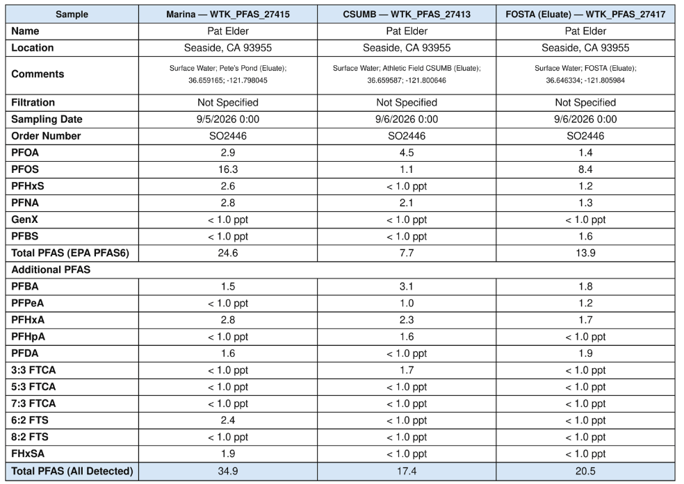
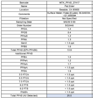
Screening samples found PFAS at the notorious “Pete’s Pond”, south of Eighth Avenue beside Promontory Housing; at the Athletic Field west of Pete’s Pond; and at the former Fort Ord Soil Treatment Area (FOSTA), located between the baseball and soccer fields. These results were from German-method eluate tests. It measures PFAS in liquid leached from the sampled material, not a direct soil concentration.
It should not be misrepresented as proof that people are breathing a stated concentration of PFAS. But it does show that PFAS were present and mobile under the conditions tested, and it warrants a real investigation of surface soil, subsurface soil, dust, stormwater, and groundwater. This concern is sharpened by the 1994 EPA Record of Decision. Section 2.10.
It allowed treated or untreated Fort Ord soil that met the standards of that era and was classified as “inert” to be reused as clean fill, road base, and landfill-cover material. PFAS were not among the contaminants characterized in that reuse scheme. PFAS-contaminated soil was likely spread across large areas of today’s campus. The “inert” classification cannot be used today as evidence that reused soil was free of PFAS. The Army and the agencies that approved reuse did not test for them.
PFAS are not all alike. PFOA, PFOS, PFHxS, PFNA, PFHxA, and fluorotelomer compounds differ in mobility, persistence, and affinity for soil and organic matter. Generally, longer-chain sulfonates such as PFOS and PFHxS tend to bind more strongly to soil, sediment, and organic carbon than shorter-chain acids. Compounds such as PFOA and PFHxA are often more mobile in water. None of this means PFOS or PFOA simply evaporates from soil. The real concern is contaminated soil becoming particulate dust when it is scraped, hauled, graded, or tracked into campus buildings.
That pathway is not speculative in the abstract. ATSDR identifies accidentally swallowing or breathing contaminated soil or dust as important PFAS exposure routes; EPA identifies contaminated soil and dust among the environmental media through which PFAS exposure may occur. NIH likewise recognizes that PFAS can move through water, air, and dust. These agencies say the pathway must be evaluated with site-specific sampling—precisely what has not yet been done at the locations where students live, recreate, and where construction is ongoing. ATSDR
The former Site 10 fire-training area near General Jim Moore Boulevard and Gigling Road presents a separate but related concern. AFFF and fuel-burning training occurred there from 1972 to 1991. The question is not whether a legacy fire-training area should be presumed to have harmed a particular person. The question is why potentially affected soil, groundwater, and dust pathways have not been fully characterized before redevelopment and construction were allowed to proceed.
CSUMB should therefore publicly request and support four immediate actions:
1. Confirm the Otter Student Union water results through repeated, independently validated tap and source-water sampling, with full laboratory reports, detection limits, methods, and results released to the public.
2. Conduct a transparent PFAS investigation at FOSTA, Pete’s Pond, the adjacent athletic field, and Site 10: surface and depth-discrete soil, leachability, settled dust, stormwater, and groundwater. Generate an analyte list of the 40 EPA compounds reported by EPA method 1633.
3. Pause soil-disturbing work throughout the campus and call for the same at the Campus Town/Site 10 area until a site-specific soil-and-dust management plan is public. That plan should include dust suppression, truck decontamination, perimeter monitoring, and worker protection. Appropriate respiratory protection should be mandated for workers.
4. Create a public Fort Ord–CSUMB PFAS dashboard that maps sampling locations, distinguishes official results from independent screening, identifies data gaps, and reports all results—not only PFOA and PFOS.
CSUMB need not declare a public-health emergency to act responsibly. It must acknowledge that a campus built on former Fort Ord cannot rely on a 1994 “inert soil” designation to answer a 2026 PFAS question. The University’s duty is simple: test thoroughly, disclose honestly, and protect the people who learn, work, play, and live here.
Surface and Subsurface PFAS Mobility, Ambient Dust Hazards, and Multiple Exposure Risks at Fort Ord Site 10 Investigating the Disconnect Between the Toxic, Historic Fire Training Area and the ‘Campus Town’ Project Currently under Construction
By Pat Elder October 1, 2026
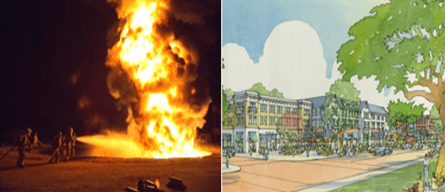
Then and now – U.S. Army photo of firefighters and an artist’s rendition of Campus Town in Seaside, CATorti Gallas & Partners
This report presents a critical evaluation of localized environmental safety, groundwater resource vulnerability, and multi-pathway exposure risks associated with legacy Per- and Polyfluoroalkyl Substances (PFAS) within the Ord Community water grid and the planned “Campus Town” mixed-use development center.
The purpose of this document is to reconcile independent field screening data with official municipal well logs, public water district records, and federal military cleanup frameworks. Historically, institutional oversight has relied on an exposure model that assumes surficial soils are stable and shallow aquifers are isolated from active municipal drinking water assets.
This report provides empirical evidence directly challenging those baseline assumptions. By demonstrating the chemical mobility of legacy contaminants at Site 10 (the former Fire Training Area and Burn Pit) and mapping the structural vulnerabilities of the regional aquifer network, this brief establishes the presence of completed and highly probable exposure pathways impacting active construction zones, pedestrian commercial nodes, and university facilities alike.
The findings compiled herein serve as a formal administrative advisory for municipal leaders, university administrators, and planning commissioners to mandate comprehensive site characterization, enforce protective occupational safety protocols, and insulate the community from long-term environmental and public health liabilities.
1. Environmental Testing Summary and Methodology – Site 10
For decades during Fort Ord’s operational history, the intersection of Gen. Jim Moore Blvd. and Gigling Road served a far grimmer purpose than the vibrant, mixed-use retail and housing hub currently envisioned. As Site 10, this specific parcel was the military’s primary Fire Training Area and Burn Pit.
Year after year, troops poured thousands of gallons of petroleum, fuel, and chemical accelerants onto the ground, ignited them, and extinguished the infernos using Aqueous Film-Forming Foam (AFFF). The toxic foam was allowed to sink directly into the unlined earth, saturating the soil profile with resilient, non-biodegradable synthetic compounds.
To evaluate the current subsurface mobility of this legacy footprint, surface soil matrices were collected and analyzed utilizing the German Eluate method. This laboratory procedure assesses whether selected PFAS can be mobilized into water under regional weather and rain conditions.
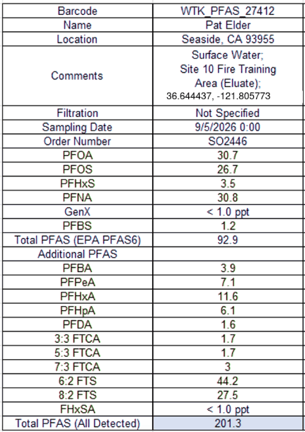
Eluate Testing Results from soil at Site 10.
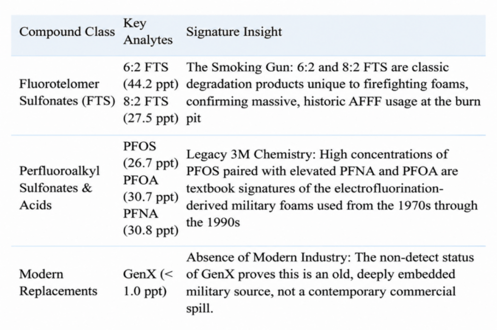
Laboratory analysis of the resulting liquid eluate yielded a Total Detected PFAS concentration of 201.3 ppt. The analytical profile reflects an industry-standard Aqueous Film-Forming Foam (AFFF) signature:
• Fluorotelomer Compounds: The sample exhibits elevated concentrations of 6:2 Fluorotelomer Sulfonate (44.2 ppt) and 8:2 FTS (27.5 ppt) [image_z8QLwE.png]. These components are characteristic of legacy fluorotelomer-based firefighting foam chemistry historically deployed at military fire training sites.
• Perfluoroalkyl Acids: The testing detected significant concentrations of long-chain compounds, including PFOS (26.7 ppt), PFOA (30.7 ppt), and PFNA (30.8 ppt).
The results for PFOS and PFOA compounds exceed the current U.S. Environmental Protection Agency (EPA) Maximum Contaminant Levels (MCLs) of 4.0 ppt enforced for public drinking water grids.
Because eluate testing isolates the dissolved liquid phase of analytes, these results demonstrate that the historical source soils at Site 10 remain saturated and capable of leaching contaminants into local shallow groundwater.
This method evaluates soil contamination by measuring the active desorbing mass that leaches into groundwater during rain events, which provides a more accurate mobile risk profile than standard bulk-soil mass testing. To mirror these exact parameters, a precise 2:1 liquid-to-solid ratio was maintained using a certified non-PFAS container. The matrix was systematically agitated over a 24-hour period and subsequently filtered. This independent screening strictly followed the same analytical EPA extraction principles utilized by commercial and military laboratories.
The new Site 10 results are significant evidence. The test demonstrates that PFAS remaining at Site 10 are not merely a historical concern or a fully immobilized burden buried in the soil. Under the test conditions, a complex mixture of PFAS entered water. That result deserves a far more complete investigation than the Army has conducted.
The regulatory framework has established an incomplete exposure model for Site 10. The Army’s primary assertion has been that human health risks are incomplete simply because the local community does not extract municipal drinking water directly from the surficial A-Aquifer. By focusing exclusively on this single water vector, the risk-assessment process effectively glosses over more complex, multi-pathway exposures.
This historical reliance is directly refuted by current data. The Army’s Quality Assurance Project Plan (QAPP) asserts that because 1,451 cubic yards of fuel-impacted soil were excavated in 1995, ‘it is unlikely that PFAS-impacted soil remains near the ground surface at Site 10.’ However, because the QAPP admits that ‘PFAS was not a contaminant of concern at that time’ this historical action entirely missed the AFFF footprint.
This systemic oversight prompted an investigation of the remediation repository itself: the Fort Ord Soil Treatment Area (FOSTA).
PFAS results from the Fort Ord Soil Treatment Area (FOSTA).
The historical record identifies FOSTA as the concrete slab situated at the former 519th Motor Pool. An independent eluate sample collected from this treatment footprint was submitted for laboratory analysis to evaluate the legacy repository.
The EPA Record of Decision, 1994 says treated or untreated soil below health-based standards were classified as “inert.” PFAS were not among the contaminants identified for routine characterization in the 1994 FOSTA reuse scheme.
The Record of Decision authorized treated or untreated soil that met then-applicable health-based standards and was classified as “inert” to be used in the OU 2 landfill cap, as road base, or as clean fill. Because that classification did not include PFAS analysis, meaning reused soil containing PFAS were liberally spread over areas that became part of the CSUMB.
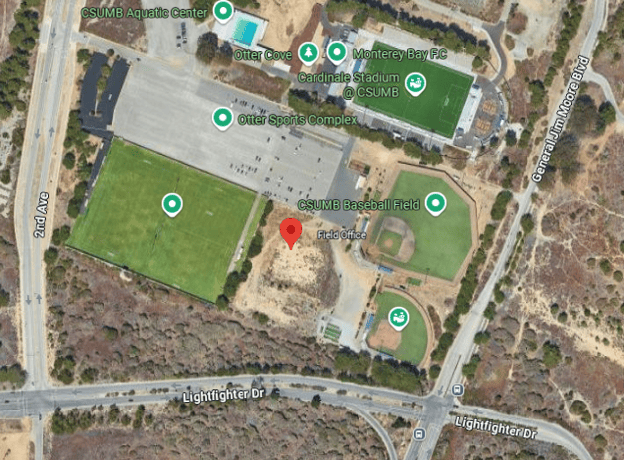
We collected a sample of contaminated soil from the FOSTA – between the baseball field and the soccer field on campus.
Everywhere we looked, we found PFAS:
• Land south of the Fire House on General Jim Moore
• Irrigation Pond in Castroville
• Locke Paddon
• CSUMB Athletic Field at Gen Jim Moore Blvd & 8th St.
• Fort Ord Dunes Park
• Pete’s Pond Area adjacent to Promontory Housing
(Stay tuned for a description of these contaminated areas in a follow-up report.)
The historical reuse framework authorized by the 1994 EPA Record of Decision created a systemic environmental vulnerability across the region. By classifying thousands of cubic yards of uncharacterized, fuel-impacted soils as “inert” based on obsolete 1990s regulatory criteria, the military liberally re-routed and spread highly contaminated matrices across parcels that now comprise the CSUMB campus.
Compared to today’s rigorous analytical testing procedures and part-per-trillion health standards, these soils were never properly vetted for highly mobile, bioaccumulative “forever chemicals” like PFAS, meaning vast swathes of the university’s surface profile rest upon an undocumented mosaic of legacy military contaminants.
Zoning Protections vs. Environmental Exposure Gaps: The Multi-Story Residential Framework.
According to the Army’s 2020 Quality Assurance Project Plan, “There are no residential, school, or daycare facilities onsite or within 200 feet of areas of potential contamination (at Site 10) and there are no sensitive terrestrial environments onsite. The property is zoned as Commercial-Mixed Use (CMX) and future land use could include both commercial and residential where PFAS-impacted soil could be exposed during development of these uses. However, Site 10 is within a designated commercial center that is part of the larger Campus Town CMX development. Per the Campus Town specific plan, future residential use is permitted but would be limited to levels above commercial spaces (second floor or higher) and the Site 10 area will be hardscaped (i.e., there are no expected exposure points for future residents) (City of Seaside, 2020).”
Crucially, while institutional Land Use Controls (LUCs) strictly restrict access to soil and groundwater at other designated parcels across the former base—such as the Main Garrison Sewage Treatment Plant and the airfield fire drill areas—no corresponding restrictive land use controls were applied to the Site 10 Burn Pit footprint within the Campus Town development zone.
Locating residences above commercial spaces may reduce direct contact with ground-level soil at the immediate building footprint, but it does not by itself resolve potential construction-worker exposure, disturbed-soil dust, groundwater migration, vapor intrusion, or off-site plume propagation questions.
Environmental Risk Assessment for ‘Campus Town’ Redevelopment
These findings introduce profound liability, environmental, and public health risks for development entities currently executing earthworks at this intersection.
Subsurface grading, excavation, and structural earthworks within an un-remediated fire training zone present an immediate pathway to generate airborne dust containing PFAS-bearing soil particles, exposing construction personnel and downwind residential tracts to inhalation pathways. Concurrently, the installation of impermeable foundations and altered stormwater routing risks modifying localized hydrology, potentially accelerating the vertical migration of dissolved analytes into underlying water resources.
Constructing a high-density commercial and residential center directly over an active, leaching chemical repository creates a permanent exposure footprint. Until this source area is comprehensively characterized, delineated, and stabilized, the proposed ‘Campus Town’ footprint remains structurally compromised by its legacy military use.
2. Comparing PFAS tap water results from Abrams Drive, Marina to CSUMB
The Abrams Dr. residence showed no PFAS while the tap water at the CSUMB Student Union Building showed potentially hazardous levels of PFAS.
Comparative analysis reveals a significant locational variance between residential inflows and municipal drinking water assets.
• Abrams Drive Residential Tap: Analysis of water samples yielded a clean baseline, with concentrations remaining below the laboratory’s specific reporting limits (non-detect) for all tested PFAS compounds
.
• CSUMB Student Union Building: Tap samples collected from the campus center revealed a Total Detected PFAS concentration of 30 ppt, driven by PFOA at 7.7 ppt, PFOS at 7.3 ppt, and PFNA at 8.1 ppt. The concentrations of individual long-chain analytes PFOA and PFOS directly exceed the U.S. EPA’s enforceable Maximum Contaminant Levels (MCLs) of 4.0 ppt.
Because municipal water distribution networks rely on dynamic blending, varying system pressures, and complex wellfield configurations, this variance indicates that local exposure risks are highly dependent on the localized aquifer extraction zones and distribution lines serving individual facilities rather than a uniform base-wide baseline.
3. The Hydrogeology of the Basin
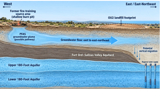
Conceptual pathway of groundwater running from the Site 10 Fire training Area to regional water supply wells.
The subsurface architecture of the former Fort Ord base governs the migration pathways of liquid contaminants. Site 10 is situated above the unconfined, surficial A-Aquifer. Hydrogeological records indicate that shallow groundwater flow moves along an easterly to east-northeasterly trajectory toward the Operable Unit 2 (OU2) Landfills area.
As groundwater moves along this east-northeast path, it approaches the geographic boundary where the Fort Ord-Salinas Valley Aquitard, the regional blue clay confining layer reaches termination edges. In areas where this clay shield is broken or absent, the shallow A-Aquifer is hydraulically connected to deeper groundwater. This structural layout creates a likely vertical migration pathway, allowing shallow liquid toxic plumes to cross the aquitard boundary and leak down into the deeper drinking water aquifers that supply regional municipal wells.
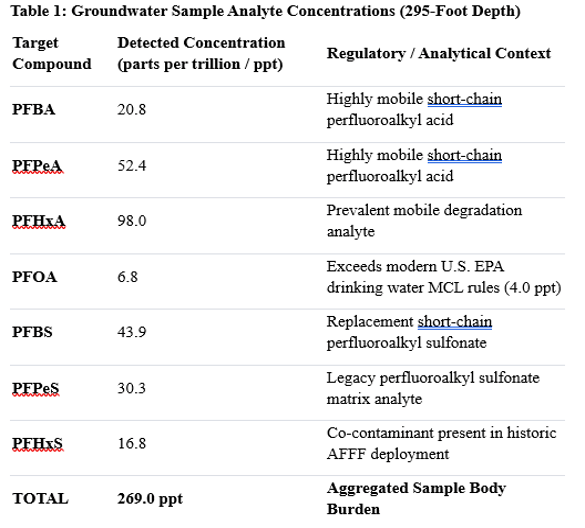
This vertical migration pattern is empirically supported by deep groundwater monitoring data collected during the site’s environmental inspection, as shown below in Table 1. A deep groundwater sample extracted 295 feet below the ground directly beneath the historical fire training footprint intercepted a significant matrix of mobile short-chain and long-chain PFAS compounds:
Finding a significant load of lighter, highly mobile short-chain analytes (such as PFHxA at 98.0 ppt) at a depth of nearly 300 feet confirms that these chemicals have successfully bypassed surficial boundary conditions.
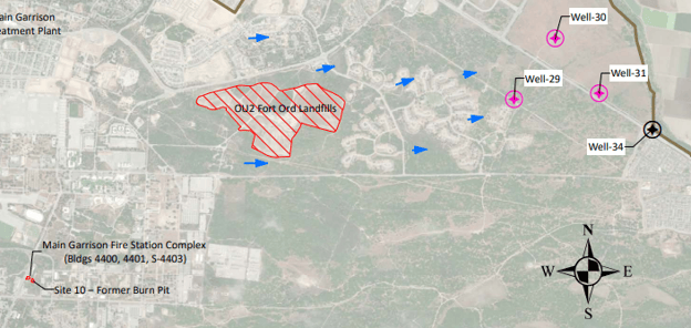
Downgradient of this transitioning Site 10 footprint sit the Marina Coast Water District (MCWD) drinking water supply wells 29, 30, 31, and 34, located approximately 3.0 miles, 3.3 miles, 3.5 miles, and 3.7 miles away, respectively. These production assets supply potable water to the City of Marina, the California State University Monterey Bay (CSUMB) campus, and parts of the City of Seaside:
• Wells 29, 30, and 31 extract groundwater from the deeper aquifer pools—specifically the 400-Foot and Lower 180-Foot Aquifer layers. Because their intakes extract from these down-gradient layers, any vertical migration through systemic discontinuities in the overlying clay shield introduces an inherent vulnerability to the water assets supporting these lines.
• Well 34 draws water from the deep 900-Foot Aquifer. This deeper zone is separated from the upper impacted strata by a dense confining layer approximately 150 feet thick, which serves to retard the vertical downward movement of shallow surface contaminants.
We don’t know for certain which well supplies which tap in the city at any certain time or day.
4. Municipal Water Grid Architecture
The non-detect findings at the Abrams Drive residential sample highlight the varying exposure risks inherent to a layered aquifer system. Portions of the regional grid draw from the deep 900-Foot Aquifer.
Conversely, the core CSUMB campus is served by the Ord Community Water System, which draws its collective volume from municipal assets—specifically Wells 29, 30, and 31—which extract from the basin’s deeper aquifer pools.
Official records from Table 7-4 of the Monterey Subbasin Groundwater Sustainability Plan (GSP) classify Well 31 within the Lower 180-Foot Aquifer, while Wells 29 and 30 are designated as drawing from the combined Lower 180-Foot / 400-Foot Aquifer zone.
While the Army’s Fort Ord Quality Assurance Project Plan (QAPP) places these production wells down-gradient of the Lower 180-Foot investigation zone rather than proving a direct, completed plume link like we see with carbon tetrachloride, trichloroethylene, and tetrachloroethylene, the system’s reliance on integrated water source blending likely means that any vertical migration introduces an inherent vulnerability to the distribution mains feeding the campus network.
Figure 2: Spatial orientation map showing the Site 10 Former Burn Pit release zone (bottom left) relative to the down-gradient migration pathway through the OU2 Fort Ord Landfills (center) and the regional municipal extraction wells (right).
5. Surface Dust Hazards
Long-chain PFAS molecules possess a high chemical affinity for adsorbing to dry surface soils. During dry seasons or heavy earth-moving activities, these contaminated micro-particles can become aerosolized as airborne dust.
Current regulatory frameworks rely on passive minimization assumptions rather than site-specific particulate risk data. The Army’s Quality Assurance Project Plan (QAPP) Volume I states: “Fieldwork activities will be conducted to minimize the release of airborne particulates within and outside of the boundaries of the site. Dust and particulates will be controlled in accordance with the Accident Prevention Plan to minimize contaminate dispersion and to protect human health and the environment. It is anticipated, based on the proposed activities, that significant dust will not be generated.”
Consequently, current occupational safety controls for the Campus Town site do not mandate specialized respiratory personal protective equipment (PPE), such as certified FFP3 or P3 particulate masks, to mitigate the soil-to-inhalation exposure pathway. However, a robust body of peer-reviewed toxicological and epidemiological literature establishes that ambient dust serves as a primary vehicle for systemic human exposure:
Following are three studies to further substantiate the point that PFAS in dust is a very real threat.
• Human exposure pathways to poly- and perfluoroalkyl substances (PFAS) from indoor media: A systematic review Environment International This systematic review evaluated the mathematical contributions of dust and air to human blood [PMC11577573]. The models demonstrated that chronic exposure to contaminated dust explicitly accounts for an estimated 25% of median human serum levels for PFHxS, 13% for PFOA, and 7% for PFNA [PMC11577573]. All three of these compounds were detected in the Site 10 soil/eluate sample.
• Per- and Polyfluoroalkyl Substances (PFAS) in Paired Blood and Dust Specimens U.S. Environmental Protection Agency (EPA) / National Children’s Study. This federal investigation analyzed how physical contact and inhalation of particulates impact vulnerable populations. The data established clear concordant exposure patterns, illustrating that elevated levels of specific long-chain PFAS found in ambient dust matrices directly mirror higher baseline serum levels in paired human subjects.
• Human Exposure:PFAS Information for Clinicians Agency for Toxic Substances and Disease Registry (ATSDR).. The ATSDR explicitly warns medical clinicians that “swallowing or breathing contaminated soil or dust” is a primary exposure route that causes PFAS to enter the bloodstream.
The most defensible conclusion is not that one soil eluate sample or one deep groundwater result predicts exactly what people will be exposed to. It is that the current investigation is inadequate to answer the question. Site 10 needs total and leachable PFAS soil testing, including shallow soil that could become dust and deeper soil beneath the 1995 excavation. It needs properly located groundwater monitoring wells at and immediately downgradient of the source, as well as along the broader northeast flow path. And it needs a transparent plan for handling soil and other materials disturbed during Campus Town redevelopment.
After decades of repeated AFFF use in an unlined burn pit, the public deserves more than a “Site Evaluation Accomplished” designation. It deserves the data needed to determine whether the remaining PFAS reservoir at Site 10 continues to feed the soil, groundwater, dust, and future redevelopment environment.
6. Conclusion and Recommendations
The data demonstrates that the historical designation of ‘Site Evaluation Accomplished’ (SEA) for Site 10 relies on an obsolete regulatory framework that fails to account for modern parts-per-trillion health standards, multi-pathway exposure vectors, or the realities of active urban redevelopment. The independent laboratory eluate metrics capturing potential surface desorbing mobility (201.3 ppt Total PFAS), paired with deep well monitoring data confirming deep vertical migration (269.0 ppt Total PFAS at 295 feet), indicate that the historical fire training pit continues to function as an active environmental source zone.
To ensure public safety, protect municipal water resources, and mitigate long-term municipal liability, the City of Seaside and the Regional Planning Commission should implement the following actions:
• Mandate Comprehensive Source Delineation: Suspend all grading and earthworks at the Campus Town parcel until a comprehensive, high-resolution grid of both total and leachable PFAS soil testing is conducted across the site’s vertical profile.
• Enforce Occupational Respiratory Controls: Require all construction personnel engaged in soil agitation, excavation, or debris clearance within the Campus Town project area to utilize specialized FFP3 or P3 particulate filtration masks to mitigate the documented airborne dust inhalation vector.
• Establish Continuous Groundwater Monitoring: Demand that the Department of the Army drill dedicated monitoring wells immediately down-gradient of the Site 10 source zone along the northeast flow path to intercept and track vertical migration toward the municipal wellfields.
• Integrate Advanced Treatment Infrastructures: Coordinate with the Marina Coast Water District to ensure robust, granular activated carbon (GAC) or ion-exchange filtration systems are actively maintained on the Ord Community distribution loops to neutralize vulnerabilities driven by dynamic water source blending.
Postscript
This independent tracking is not an academic exercise in regulatory compliance; instead, it is a direct response to a profound systemic failure that impacts human lives.
See Julie Akey’sdatabase of more than 2,000 peoplewho suffer with disease or are deceased and lived on the former Fort Ord or on lands that were later developed. You can contribute to ongoing Fort Ord investigatory work. Please, go here, to the bottom of the page, to contribute: https://www.fortordcontamination.org/
The findings presented here are true to the absolute limit of available data, executed by one individual and sustained by the micro-contributions of a community demanding basic transparency. While institutional watchdogs hide behind the technical nuances of dynamic water blending and unmapped plume edges to minimize their liability, their collective complacency has created a severe exposure footprint.
A sleepy EPA, a compliant state environmental apparatus, and city officials eager to secure development tax revenues have allowed a highly active chemical source zone to be treated as ordinary construction dirt.
By treating this exclusively as a static groundwater issue, the regulatory framework deliberately ignores the multi-pathway exposure pathways that carry an immediate human cost. The systemic reuse of uncharacterized military soils has created an undocumented mosaic of contaminants beneath the local surface profile.
The consequences of this institutional negligence are visible in the surrounding community, where public tracking and reports have identified a cluster of eight individuals—including two recent cases within the university’s student housing complexes—who attended the institution and subsequently developed leukemia and other advanced cancers.
When public agencies utilize the Army’s antiquated regulatory findings to walk away from a legacy burn pit, they are not practicing sound science; they are making a calculated choice to tolerate an unmitigated public health vulnerability. By prioritizing corporate real estate timelines over the physical well-being of the construction crews, students, and families who inhabit this land, these institutions have transformed a failure of environmental stewardship into a profound moral crisis.