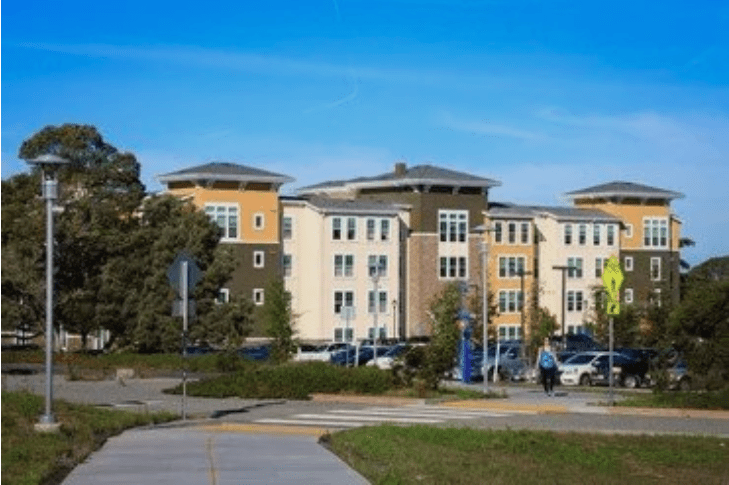
When public agencies utilize the Army’s antiquated regulatory findings to walk away from a legacy burn pit, they are not practicing sound science; they are making a calculated choice to tolerate an unmitigated public health vulnerability. By prioritizing corporate real estate timelines over the physical well-being of the construction crews, students, and families who inhabit this land, these institutions have transformed a failure of environmental stewardship into a profound moral crisis.
From Military Poisons:
Surface and Subsurface PFAS Mobility, Ambient Dust Hazards, and Multiple Exposure Risks at Fort Ord Site 10
Investigating the Disconnect Between the Toxic, Historic Fire Training Area and the ‘Campus Town’ Project Currently under Construction
By Pat Elder
October 1, 2026
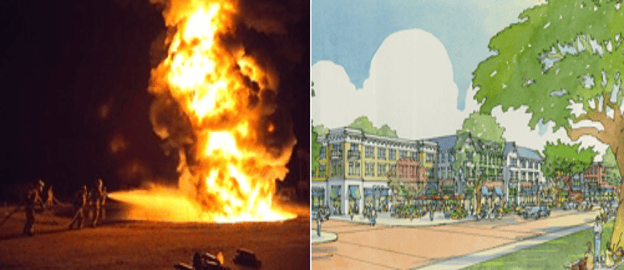
Then and now – U.S. Army photo of firefighters and an artist’s rendition of Campus Town in Seaside, CA Torti Gallas & Partners
This report presents a critical evaluation of localized environmental safety, groundwater resource vulnerability, and multi-pathway exposure risks associated with legacy Per- and Polyfluoroalkyl Substances (PFAS) within the Ord Community water grid and the planned “Campus Town” mixed-use development center.
The purpose of this document is to reconcile independent field screening data with official municipal well logs, public water district records, and federal military cleanup frameworks. Historically, institutional oversight has relied on an exposure model that assumes surficial soils are stable and shallow aquifers are isolated from active municipal drinking water assets.
This report provides empirical evidence directly challenging those baseline assumptions. By demonstrating the chemical mobility of legacy contaminants at Site 10 (the former Fire Training Area and Burn Pit) and mapping the structural vulnerabilities of the regional aquifer network, this brief establishes the presence of completed and highly probable exposure pathways impacting active construction zones, pedestrian commercial nodes, and university facilities alike.
The findings compiled herein serve as a formal administrative advisory for municipal leaders, university administrators, and planning commissioners to mandate comprehensive site characterization, enforce protective occupational safety protocols, and insulate the community from long-term environmental and public health liabilities.
1. Environmental Testing Summary and Methodology – Site 10
For decades during Fort Ord’s operational history, the intersection of Gen. Jim Moore Blvd. and Gigling Road served a far grimmer purpose than the vibrant, mixed-use retail and housing hub currently envisioned. As Site 10, this specific parcel was the military’s primary Fire Training Area and Burn Pit.
Year after year, troops poured thousands of gallons of petroleum, fuel, and chemical accelerants onto the ground, ignited them, and extinguished the infernos using Aqueous Film-Forming Foam (AFFF). The toxic foam was allowed to sink directly into the unlined earth, saturating the soil profile with resilient, non-biodegradable synthetic compounds.
To evaluate the current subsurface mobility of this legacy footprint, surface soil matrices were collected and analyzed utilizing the German Eluate method. This laboratory procedure assesses whether selected PFAS can be mobilized into water under regional weather and rain conditions.
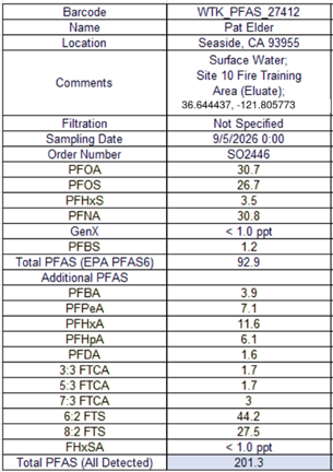
Eluate Testing Results from soil at Site 10.
Laboratory analysis of the resulting liquid eluate yielded a Total Detected PFAS concentration of 201.3 ppt. The analytical profile reflects an industry-standard Aqueous Film-Forming Foam (AFFF) signature:
• Fluorotelomer Compounds: The sample exhibits elevated concentrations of 6:2 Fluorotelomer Sulfonate (44.2 ppt) and 8:2 FTS (27.5 ppt) [image_z8QLwE.png]. These components are characteristic of legacy fluorotelomer-based firefighting foam chemistry historically deployed at military fire training sites.
• Perfluoroalkyl Acids: The testing detected significant concentrations of long-chain compounds, including PFOS (26.7 ppt), PFOA (30.7 ppt), and PFNA (30.8 ppt).
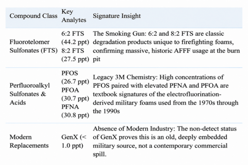
The results for PFOS and PFOA compounds exceed the current U.S. Environmental Protection Agency (EPA) Maximum Contaminant Levels (MCLs) of 4.0 ppt enforced for public drinking water grids.
Because eluate testing isolates the dissolved liquid phase of analytes, these results demonstrate that the historical source soils at Site 10 remain saturated and capable of leaching contaminants into local shallow groundwater.
This method evaluates soil contamination by measuring the active desorbing mass that leaches into groundwater during rain events, which provides a more accurate mobile risk profile than standard bulk-soil mass testing. To mirror these exact parameters, a precise 2:1 liquid-to-solid ratio was maintained using a certified non-PFAS container. The matrix was systematically agitated over a 24-hour period and subsequently filtered. This independent screening strictly followed the same analytical EPA extraction principles utilized by commercial and military laboratories.
The new Site 10 results are significant evidence. The test demonstrates that PFAS remaining at Site 10 are not merely a historical concern or a fully immobilized burden buried in the soil. Under the test conditions, a complex mixture of PFAS entered water. That result deserves a far more complete investigation than the Army has conducted.
The regulatory framework has established an incomplete exposure model for Site 10. The Army’s primary assertion has been that human health risks are incomplete simply because the local community does not extract municipal drinking water directly from the surficial A-Aquifer. By focusing exclusively on this single water vector, the risk-assessment process effectively glosses over more complex, multi-pathway exposures.
This historical reliance is directly refuted by current data. The Army’s Quality Assurance Project Plan (QAPP) asserts that because 1,451 cubic yards of fuel-impacted soil were excavated in 1995, ‘it is unlikely that PFAS-impacted soil remains near the ground surface at Site 10.’ However, because the QAPP admits that ‘PFAS was not a contaminant of concern at that time’ this historical action entirely missed the AFFF footprint.
This systemic oversight prompted an investigation of the remediation repository itself: the Fort Ord Soil Treatment Area (FOSTA).
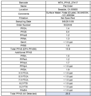
PFAS results from the Fort Ord Soil Treatment Area (FOSTA).
The historical record identifies FOSTA as the concrete slab situated at the former 519th Motor Pool. An independent eluate sample collected from this treatment footprint was submitted for laboratory analysis to evaluate the legacy repository.
The EPA Record of Decision, 1994 says treated or untreated soil below health-based standards were classified as “inert.” PFAS were not among the contaminants identified for routine characterization in the 1994 FOSTA reuse scheme.
The Record of Decision authorized treated or untreated soil that met then-applicable health-based standards and was classified as “inert” to be used in the OU 2 landfill cap, as road base, or as clean fill. Because that classification did not include PFAS analysis, meaning reused soil containing PFAS were liberally spread over areas that became part of the CSUMB.
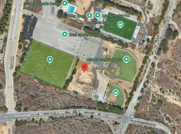
We collected a sample of contaminated soil from the FOSTA – between the baseball field and the soccer field on campus.
Everywhere we looked, we found PFAS:
- • Land south of the Fire House on General Jim Moore
- • Irrigation Pond in Castroville
- • Locke Paddon
- • CSUMB Athletic Field at Gen Jim Moore Blvd & 8th St.
- • Fort Ord Dunes Park
- • Pete’s Pond Area adjacent to Promontory Housing
(Stay tuned for a description of these contaminated areas in a follow-up report.)
The historical reuse framework authorized by the 1994 EPA Record of Decision created a systemic environmental vulnerability across the region. By classifying thousands of cubic yards of uncharacterized, fuel-impacted soils as “inert” based on obsolete 1990s regulatory criteria, the military liberally re-routed and spread highly contaminated matrices across parcels that now comprise the CSUMB campus.
Compared to today’s rigorous analytical testing procedures and part-per-trillion health standards, these soils were never properly vetted for highly mobile, bioaccumulative “forever chemicals” like PFAS, meaning vast swathes of the university’s surface profile rest upon an undocumented mosaic of legacy military contaminants.
Zoning Protections vs. Environmental Exposure Gaps: The Multi-Story Residential Framework.
According to the Army’s 2020 Quality Assurance Project Plan, “There are no residential, school, or daycare facilities onsite or within 200 feet of areas of potential contamination (at Site 10) and there are no sensitive terrestrial environments onsite. The property is zoned as Commercial-Mixed Use (CMX) and future land use could include both commercial and residential where PFAS-impacted soil could be exposed during development of these uses. However, Site 10 is within a designated commercial center that is part of the larger Campus Town CMX development. Per the Campus Town specific plan, future residential use is permitted but would be limited to levels above commercial spaces (second floor or higher) and the Site 10 area will be hardscaped (i.e., there are no expected exposure points for future residents) (City of Seaside, 2020).”
Crucially, while institutional Land Use Controls (LUCs) strictly restrict access to soil and groundwater at other designated parcels across the former base—such as the Main Garrison Sewage Treatment Plant and the airfield fire drill areas—no corresponding restrictive land use controls were applied to the Site 10 Burn Pit footprint within the Campus Town development zone.
Locating residences above commercial spaces may reduce direct contact with ground-level soil at the immediate building footprint, but it does not by itself resolve potential construction-worker exposure, disturbed-soil dust, groundwater migration, vapor intrusion, or off-site plume propagation questions.
Environmental Risk Assessment for ‘Campus Town’ Redevelopment
These findings introduce profound liability, environmental, and public health risks for development entities currently executing earthworks at this intersection.
Subsurface grading, excavation, and structural earthworks within an un-remediated fire training zone present an immediate pathway to generate airborne dust containing PFAS-bearing soil particles, exposing construction personnel and downwind residential tracts to inhalation pathways. Concurrently, the installation of impermeable foundations and altered stormwater routing risks modifying localized hydrology, potentially accelerating the vertical migration of dissolved analytes into underlying water resources.
Constructing a high-density commercial and residential center directly over an active, leaching chemical repository creates a permanent exposure footprint. Until this source area is comprehensively characterized, delineated, and stabilized, the proposed ‘Campus Town’ footprint remains structurally compromised by its legacy military use.
2. Comparing PFAS tap water results from Abrams Drive, Marina to CSUMB
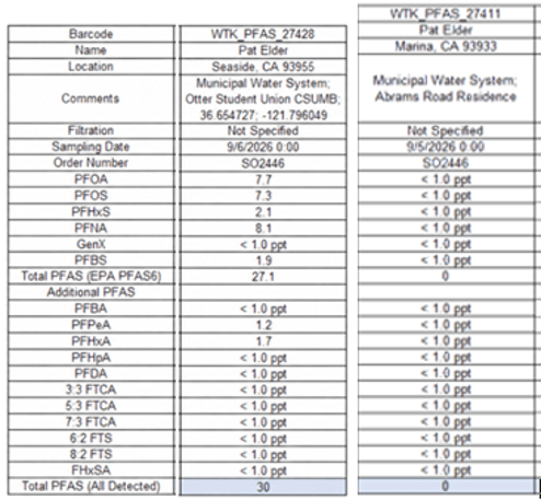
The Abrams Dr. residence showed no PFAS while the tap water at the CSUMB Student Union Building showed potentially hazardous levels of PFAS.
Comparative analysis reveals a significant locational variance between residential inflows and municipal drinking water assets.
• Abrams Drive Residential Tap: Analysis of water samples yielded a clean baseline, with concentrations remaining below the laboratory’s specific reporting limits (non-detect) for all tested PFAS compounds
.
• CSUMB Student Union Building: Tap samples collected from the campus center revealed a Total Detected PFAS concentration of 30 ppt, driven by PFOA at 7.7 ppt, PFOS at 7.3 ppt, and PFNA at 8.1 ppt. The concentrations of individual long-chain analytes PFOA and PFOS directly exceed the U.S. EPA’s enforceable Maximum Contaminant Levels (MCLs) of 4.0 ppt.
Because municipal water distribution networks rely on dynamic blending, varying system pressures, and complex wellfield configurations, this variance indicates that local exposure risks are highly dependent on the localized aquifer extraction zones and distribution lines serving individual facilities rather than a uniform base-wide baseline.
3. The Hydrogeology of the Basin
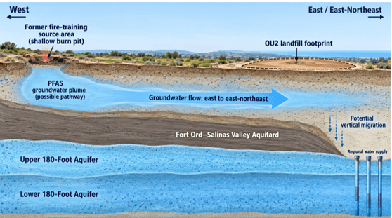
Conceptual pathway of groundwater running from the Site 10 Fire training Area to regional water supply wells.
Continue reading “– New investigation shows multiple exposure risks at former Fort Ord — at CSUMB and Campus Town development”